
 The research of College of Natural Resources professors Dave Tilotta, Stacy Nelson and Tom Colson along with graduate students Tyler Strayhorn and Brett Harris are featured in “The North Carolina Coast,” the Winter 2011 issue of Results – the Research and Innovation Magazine at North Carolina State University.
Here are two examples of how we’re improving the lives of the people, plants and animals who populate our coast.
Tools Needed to Bounce Back after the Storm
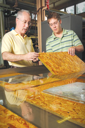
Dr. Dave Tilotta (left) and Tyler Strayhorn, an M.S. candidate in Forest Biomaterials, use flood-simulation tanks to test building material resiliency to river water and sea water.
Dr. Dave Tilotta is trying to find ways to make building materials more storm-proof. An associate professor and extension specialist in the Department of Forest Biomaterials, Tilotta is NC State’s point man for the DHS’ Resilient Home Program. The effort came about after Hurricane Katrina, when officials realized there was no single place for homeowners whose houses had been damaged in a natural disaster to seek information.
Tilotta’s team worked with program members at Savannah River National Laboratory, the U.S. Army Corps of Engineers, and Clemson University to create YouTube videos and other means to disseminate information on issues like mold mitigation and ways to retrofit homes. They also developed performance-based guidelines to encourage construction of buildings to better withstand high winds.
“The best way for a community to recover from a natural disaster is to get people back into their homes
as quickly as possible.”
The Resilient Home Program is now ramping up research efforts, such as determining how resistant building materials are to floodwaters. “FEMA provides guidance on when materials should be considered too damaged for use, but there’s no science behind them,” Tilotta says. His team dunks flooring into specially built flood-simulation tanks in Hodges Laboratory that contain river water or saltwater. After soaking the boards for up to a couple of weeks and then drying them out, they put the materials through a battery of tests to see how well they meet performance standards like weight-bearing capacity.
Eventually, Tilotta says, they will test wall studs and other materials as well. “The best way for a community to recover from a natural disaster is to get people back into their homes as quickly as possible,” he says. “Our research and education efforts are designed with that goal in mind.”
Eye in Sky Can See Underwater Greenery
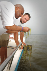
Dr. Stacy Nelson and Brett Hartis, a Ph.D. candidate in Forestry and Environmental Resources, examine underwater vegetation in the Currituck Sound.
Under a searing summer sun, an NC State research team takes a small boat out onto Currituck Sound and drops some lines in the water. This is no ordinary fishing expedition, however. The group is reeling in samples of plants growing in the sediment a few feet below the surface so they can correlate their findings with images snapped by a satellite soaring more than 275 miles over their heads.
Determining the location and variety of vegetation submerged in a body of water has always been a labor-intensive process. It’s also one with the potential for inaccuracy, as researchers pull samples from various points and then extrapolate their findings over a wider area. The North Carolina Department of Transportation (NCDOT) asked Dr. Stacy Nelson, associate professor in the Department of Forestry and Environmental Resources, to find an easier and more reliable way to inventory underwater plants.
Submerged vegetation often presents planning problems for NCDOT engineers on projects that cross water. They must either avoid areas teeming with plants because those spots often are also teeming with fish or mitigate the construction damage by replanting elsewhere. “If you don’t have an accurate inventory of what’s there,” Nelson says, “you don’t know where to avoid and what to mitigate.”
Nelson, who works in the College of Natural Resources’ (CNR) Center for Earth Observation, believes high-resolution satellite images can be used to pinpoint submerged vegetation. He says he had good results using satellite photos to map lakes in Michigan a few years back, and now he is tapping into more detailed photos from a commercial satellite called Quickbird to develop a mathematical model for predicting what plants are where underwater. The model also will include data on water quality and the “reflective signature” of various plants.
Submerged vegetation often presents planning problems for NCDOT engineers
on projects that cross water.
Getting the signature for each species is where the boat trips on Currituck Sound come in. “Water either scatters or absorbs the reflective energy the satellite is trying to capture, so there’s little left to develop a signature,” Nelson says. Together with Dr. Tom Colson, a geographic information systems expert in CNR, and two graduate students, he had to conduct a manual inventory so they could match their findings to the Quickbird photos. They collected samples at 276 points over 270 square miles three times during the summer as vegetation changed, noting the global-positioning satellite coordinates of each point so they would sample the exact spots each time. “If we can use the model to preserve healthy plant communities,” Nelson says, “we can boost the underwater ecology along our coast.”
Results: Research and Innovation at North Carolina State University is published three times yearly by the Office of the Vice Chancellor for Research and Innovation.
Editor – Matthew Burns
Photography: Roger Winstead